Gym nearby 警光跆拳道館
Taiwan
Gym nearby 警光跆拳道館
警光跆拳道館
2, Lane 30, Deshan Street, 807, Kaohsiung City, TW Taiwan
contacts phone
:
+886 7 345 9919
Latitude:
22.646246
, Longitude:
120.3173029
larger map & directions
read more
nearest Gym
201 m
Sinlong36健康俱樂部
807中華民國高雄市三民區興隆街36號 807中華民國高雄市三民區興隆街36號
Gym
read more
433 m
君強跆拳道
No. 87號, Yanqing Street, Sanmin District
Gym
read more
625 m
囍艾.fit 囍兒 皮拉提斯
鼎成街29號, Sanmin District
Gym
read more
680 m
健身工廠 Fitness Factory 九如廠
No. 1, Qingyun Street, Sanmin District
Gym
read more
740 m
宮廷泰式養生館
宮廷 泰 式 養生 館
Gym
read more
817 m
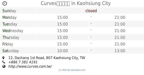
Curves
3 樓, No. 805, Jiuru 1st Road, Sanmin District
Gym
read more
1.003 km
返老還童-科工館-練功場
三民區安發里
Gym
read more
1.075 km
返老還童-正興國小-練功場
三民區寶興里
Gym
read more
1.113 km
張鈞弼運動舞蹈教室
號, No. 42, 建國二路, 三民區
Gym
read more
1.118 km
楊老師瑜珈
No. 82-27號, Baoxing Road, Sanmin District
Gym
read more
1.23 km
藍色公路游泳池
No. 151號, Xianzheng Road, Lingya District
Gym
read more
1.345 km
Curves高雄大昌店
No. 12, Dachang 1st Road, Sanmin District
Gym
read more
1.394 km
單槓世界街頭健身訓練中心
No. 579號8樓, Juemin Road, Sanmin District
Gym
read more
1.516 km
MAX格鬥館
號 5F, No. 193, Bade 1st Road, Xinxing District
Gym
read more
1.521 km
安蕎體能運動館
No. 240, Qixian 1st Road, Xinxing District
Gym
read more
1.78 km
富士活力館-自由店
自由二路118號地下1樓, Zuoying District
Gym
read more
1.915 km
Shri yoga
3F-2, No. 332, Mingcheng 2nd Road, Zuoying District
Gym
read more
1.925 km
律動健康生活館
No. 33, Zhongzheng 3rd Road, Xinxing District
Gym
read more
1.974 km
東東娛樂場
號, No. 12, 八德二路, 新興區
Gym
read more
2 km
Curves女性專用30分鐘健身中心
高雄市三民區裕誠路72號2樓
Gym
read more
2.039 km
佐登妮絲美容機構
No. 394號, Mingcheng 2nd Road, Zuoying District
Gym
read more
2.167 km
Bronze Gym
No. 19, Fuxing 1st Road, Xinxing District
Gym
read more
2.219 km
I-Bounce 親子互動教室
輔仁路377號, Lingya District
Gym
read more
2.326 km
SuperFIT私人健身會館-左營博愛館
No. 312, Bo'ai 2nd Road, Zuoying District
Gym
read more
2.525 km
Madtown Barbell 健身房
No. 315號, Minghua Road, Gushan District
Gym
read more
📑
all categories
Accounting
Administrative area level 1
Administrative area level 2
Airport
Amusement park
Aquarium
Art gallery
Atm
Bakery
Bank
Bar
Beauty salon
Bicycle store
Book store
Bowling alley
Bus station
Cafe
Campground
Car dealer
Car rental
Car repair
Car wash
Casino
Cemetery
Church
City hall
Clothing store
Colloquial area
Convenience store
Courthouse
Dentist
Department store
Doctor
Electrician
Electronics store
Embassy
Establishment
Finance
Fire station
Florist
Food
Funeral home
Furniture store
Gas station
General contractor
Grocery or supermarket
Gym
Hair care
Hardware store
Health
Hindu Temple
Home goods store
Hospital
Insurance agency
Jewelry store
Laundry
Lawyer
Library
Light rail station
Liquor store
Local government office
Locality
Locksmith
Lodging
Meal delivery
Meal takeaway
Mosque
Movie rental
Movie theater
Moving company
Museum
Natural feature
Neighborhood
Night club
Painter
Park
Parking
Pet store
Pharmacy
Physiotherapist
Place of worship
Plumber
Point of interest
Police
Post office
Premise
Real estate agency
Restaurant
Roofing contractor
Route
Rv park, camping
School
Shoe store
Shopping mall
Spa
Stadium
Storage
Store
Subpremise
Subway station
Supermarket
Synagogue
Taxi stand
Train station
Transit station
Travel agency
University
Veterinary care
Zoo
administrative area level 3
administrative area level 4
↑