Museum nearby Pine Garden
Taiwan
Museum nearby Pine Garden
Pine Garden
65, Songyuan Street, 970, Hualien County, TW Taiwan
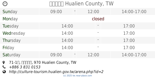
contacts phone
:
+886 3 835 6510
website:
www.pinegarden.com.tw
Latitude:
23.9828055
, Longitude:
121.6154938
larger map & directions
read more
nearest Museum
243 m
花蓮港山林事業所
No. 10, Jinghua Street, Hualien City
Museum
read more
650 m
Taipingyang3Ddejing Park
號, No. 138, Haibin Street, Hualien City
Museum
read more
706 m
洄瀾人文館
花蓮市公正街14號
Museum
read more
736 m
花蓮檢察長宿舍
No. 23, Sanmin Street, Hualien City
Museum
read more
958 m
Wata-Art
No. 14, Xingang Street, Hualien City
Museum
read more
1.054 km
花蓮鐵道文化園區二館
No. 460, Fujian Street, Hualien City
Museum
read more
1.124 km
美崙山生態展示館
No. 25之2, Shangzhi Road, Hualien City
Museum
read more
1.18 km
美崙山公園科博館
No. 26, Shangzhi Road, Hualien City
Museum
read more
1.245 km
靈通寶院
石 藝 大街 16-2
Museum
read more
1.278 km
乙皮畫廊
號, No. 144, 中華路, 花蓮市
Museum
read more
1.283 km
文化午茶體驗
No. 14, 明義街195巷, Hualien City
Museum
read more
1.337 km
台日文化有限公司
No. 144, Zhonghua Road, Hualien City
Museum
read more
1.567 km
朝瓏地球科學館
No. 21, Guoxing 2nd Street, Hualien City
Museum
read more
1.596 km
沛石館
Hualien City
Museum
read more
1.596 km
嘉雲南
Hualien City
Museum
read more
1.804 km
黃兆伸陶藝創作館
號, No. 152中福路, 花蓮市
Museum
read more
1.894 km
花蓮玫瑰石藝術博物館
No. 77號, Nanbin Road, Hualien City
Museum
read more
2.415 km
大陳故事館
No. 71-1號, 民意里民光, Hualien City
Museum
read more
2.648 km
文弘玫瑰石工作室
No. 239-3, Section 4, Zhongyang Road, Hualien City
Museum
read more
5.112 km
Chisingtan Katsuo Museum
No. 148, Qixing Street, Xincheng Township
Museum
read more
6.487 km
曼波博物館
Xincheng Township
Museum
read more
31.167 km
賀田金三郎研究所
No. 11, Minzhi Road, Fenglin Township
Museum
read more
📑
all categories
Accounting
Administrative area level 1
Administrative area level 2
Airport
Amusement park
Aquarium
Art gallery
Atm
Bakery
Bank
Bar
Beauty salon
Bicycle store
Book store
Bowling alley
Bus station
Cafe
Campground
Car dealer
Car rental
Car repair
Car wash
Casino
Cemetery
Church
City hall
Clothing store
Colloquial area
Convenience store
Courthouse
Dentist
Department store
Doctor
Electrician
Electronics store
Embassy
Establishment
Finance
Fire station
Florist
Food
Funeral home
Furniture store
Gas station
General contractor
Grocery or supermarket
Gym
Hair care
Hardware store
Health
Hindu Temple
Home goods store
Hospital
Insurance agency
Jewelry store
Laundry
Lawyer
Library
Light rail station
Liquor store
Local government office
Locality
Locksmith
Lodging
Meal delivery
Meal takeaway
Mosque
Movie rental
Movie theater
Moving company
Museum
Natural feature
Neighborhood
Night club
Painter
Park
Parking
Pet store
Pharmacy
Physiotherapist
Place of worship
Plumber
Point of interest
Police
Post office
Premise
Real estate agency
Restaurant
Roofing contractor
Route
Rv park, camping
School
Shoe store
Shopping mall
Spa
Stadium
Storage
Store
Subpremise
Subway station
Supermarket
Synagogue
Taxi stand
Train station
Transit station
Travel agency
University
Veterinary care
Zoo
administrative area level 3
administrative area level 4
↑