Gym nearby 伍十撞球
Taiwan
Gym nearby 伍十撞球
伍十撞球
119之2號 5樓, Dachang 2nd Road, 807, Kaohsiung City, TW Taiwan
contacts phone
:
+886 7 381 7677
Latitude:
22.6423281
, Longitude:
120.3319755
larger map & directions
read more
nearest Gym
306 m
單槓世界街頭健身訓練中心
No. 579號8樓, Juemin Road, Sanmin District
Gym
read more
477 m
楊老師瑜珈
No. 82-27號, Baoxing Road, Sanmin District
Gym
read more
527 m
返老還童-正興國小-練功場
三民區寶興里
Gym
read more
944 m
I-Bounce 親子互動教室
輔仁路377號, Lingya District
Gym
read more
1.048 km
返老還童-科工館-練功場
三民區安發里
Gym
read more
1.084 km
舞動十分主題會館
黃興路130號, Sanmin District
Gym
read more
1.157 km
藍色公路游泳池
No. 151號, Xianzheng Road, Lingya District
Gym
read more
1.188 km
Curves
3 樓, No. 805, Jiuru 1st Road, Sanmin District
Gym
read more
1.213 km
綠種子舞蹈空間
號, No. 79, 褒揚街, 三民區
Gym
read more
1.248 km
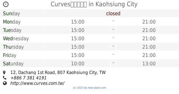
Curves高雄大昌店
No. 12, Dachang 1st Road, Sanmin District
Gym
read more
1.254 km
鼎鋒運動教室
No. 99, Chenghe Road, Sanmin District
Gym
read more
1.309 km
穿山甲運動廣場
穿山甲
Gym
read more
1.314 km
美憶運動館-武廟館
武廟路136號, 2樓, Lingya District
Gym
read more
1.42 km
100M above ground Robert
802, 建民路, 苓雅區
Gym
read more
1.433 km
Sinlong36健康俱樂部
807中華民國高雄市三民區興隆街36號 807中華民國高雄市三民區興隆街36號
Gym
read more
1.437 km
Fitness Factory factory Fengshan
No. 466-1, Chengqing Road, Sanmin District
Gym
read more
1.457 km
張微微舞蹈工作室
號 5 樓, No. 284, Zhongzheng 1st Road, Lingya District
Gym
read more
1.534 km
中正網球場 (俱樂部)
號, No. 19, 建民路, 苓雅區
Gym
read more
1.567 km
警光跆拳道館
號, No. 2, Lane 30, Deshan Street, Sanmin District
Gym
read more
1.58 km
香水SPA會館
No. 271號, Zhongzheng 1st Road, Lingya District
Gym
read more
1.77 km
Anytime Fitness 高雄文山店24小時健身房
No. 138, Wenbin Road, Fengshan District
Gym
read more
1.771 km
健身工廠 Fitness Factory 九如廠
No. 1, Qingyun Street, Sanmin District
Gym
read more
1.812 km
高雄市體育處健身中心
苓雅區福西里
Gym
read more
1.883 km
囍艾.fit 囍兒 皮拉提斯
鼎成街29號, Sanmin District
Gym
read more
1.979 km
美憶運動健康館
二樓, No. 375-1, Section 2, Qingnian Road, Fengshan District
Gym
read more
📑
all categories
Accounting
Administrative area level 1
Administrative area level 2
Airport
Amusement park
Aquarium
Art gallery
Atm
Bakery
Bank
Bar
Beauty salon
Bicycle store
Book store
Bowling alley
Bus station
Cafe
Campground
Car dealer
Car rental
Car repair
Car wash
Casino
Cemetery
Church
City hall
Clothing store
Colloquial area
Convenience store
Courthouse
Dentist
Department store
Doctor
Electrician
Electronics store
Embassy
Establishment
Finance
Fire station
Florist
Food
Funeral home
Furniture store
Gas station
General contractor
Grocery or supermarket
Gym
Hair care
Hardware store
Health
Hindu Temple
Home goods store
Hospital
Insurance agency
Jewelry store
Laundry
Lawyer
Library
Light rail station
Liquor store
Local government office
Locality
Locksmith
Lodging
Meal delivery
Meal takeaway
Mosque
Movie rental
Movie theater
Moving company
Museum
Natural feature
Neighborhood
Night club
Painter
Park
Parking
Pet store
Pharmacy
Physiotherapist
Place of worship
Plumber
Point of interest
Police
Post office
Premise
Real estate agency
Restaurant
Roofing contractor
Route
Rv park, camping
School
Shoe store
Shopping mall
Spa
Stadium
Storage
Store
Subpremise
Subway station
Supermarket
Synagogue
Taxi stand
Train station
Transit station
Travel agency
University
Veterinary care
Zoo
administrative area level 3
administrative area level 4
↑